The year 2023 marked the beginning of an onset of climatic changes regarding flooding in Stockton and Delta communities. In January, atmospheric river storms hit California and exposed decades of disinvestment in the Delta’s levee infrastructure and emergency response system. Mormon Slough in particular faces threats on both sides. Southeast within Mormon Slough, near the Stockton diverting canal, the Calaveras River system does not only face erosion issues but extreme periods of rain and rapid melting snowpack can expose this river to excessive flow that could overtop and flood communities. Similarly, near the terminus of Mormon Slough by the Stockton Deep Water Shipping Channel, the San Joaquin River faces similar risks of overtopping coupled with sea-level rise and King Delta tides. The channel was rejected for levee upgrades in previous decades by the Army Corps of Engineers due to low benefit-cost ratios and low economic development analysis.
In March, Restore the Delta partnered with several stakeholders to begin the creation of a plan to restore Mormon Slough and subsequently formed the Mormon Slough Restoration Association -a coalition built by and for community water safety, health, and wellness. We are working closely with tribal governments, community-based organizations, and our local flood agency to shape the Mormon Slough Restoration project through the lens of environmental justice communities and tribal groups. This includes engaging with communities in the planning process from the start! This is done through participating in several community meetings, and vision/planning sessions.
Restore the Delta plays the role of a convener and the project itself is co-led by their Flood and Land Restoration Manager Artie Valencia. The restoration coalition hopes to not only create a plan for needed flood infrastructure but also to implement a nature-based project that will provide multi-benefits for regional environmental and economic development needs, fitting into an urban context. Additionally, the Mormon Slough Restoration Association is partnering with housing agencies to create an adjacent plan for the unhoused populations, and to create additional affordable housing. The overall goal is to begin creating an inclusive, holistic plan with enhanced flood protection, green spaces, increased flows leading to mitigation for harmful algae blooms and safe recreation, community-driven housing, and a community-led economic development plan with community-based entrepreneurial districts.
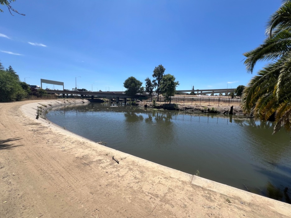
Image 1 shows the watered stretch of Mormon Slough looking up terminus near the Stockton Deep Water Shipping Channel and San Joaquin River.
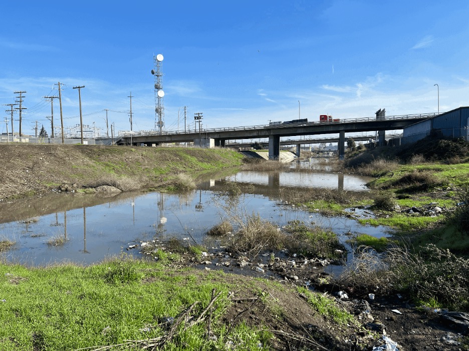
Image 2: The unwatered parts of Mormon Slough near W. Scotts and S. Commerce St. during the January 2023 Atmospheric River Storms.
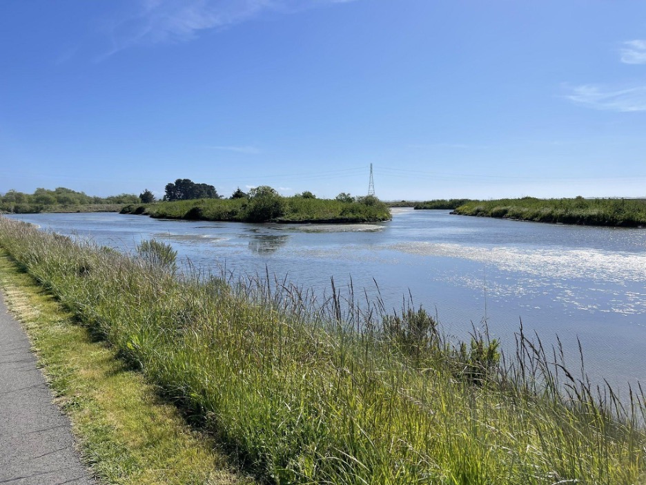
Image 3: The Arcata Marsh and Wildlife Sanctuary is home to the City of Arcata’s innovative wastewater treatment facility. The sanctuary is 307 acres, including freshwater marshes, salt marsh, tidal sloughs, grassy uplands, mudflats, brackish marsh, approximately 5 miles of walking and biking paths, and an Interpretive Center.
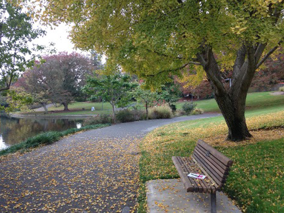
Image 4: The UC Davis Arboretum Waterway Flood Protection and Habitat Enhancement Project addresses core UC Davis sustainability goals, including a low-impact development approach, stormwater management, and key elements of the Living Landscape Adaptation Plan, which prepares campus for the impacts of climate change.
Before (Current Conditions): Image 1 shows the watered stretch of Mormon Slough looking up terminus near the Stockton Deep Water Shipping Channel and San Joaquin River. The water is not safe to access due to agricultural runoff and harmful algae blooms in the summer. The area beyond the banks is dry, with low-lying shrubs and several invasive trees and vegetation species. Overall, there is little to no canopy cover to give residents relief on hot summer days. Generally, this location is loitered and is a prominent area for the unhoused to reside.
Image 2 depicts the unwatered part of Mormon Slough near W. Scotts and S. Commerce St. during the January Atmospheric River Storms in 2023. Below a highway, its waters are filled with debris and overgrown vegetation. Discarded trash litters the muddy banks, reflecting years of neglect and environmental disarray. Overall, there is no canopy cover as there are no trees at this site. Instead, the site is infected with invasive species (such as bushes and yellow Eurasian grasses) that often catch fire. The scene is a stark reminder of the challenges facing urban waterways amidst the human impact.
After: Image 3 and 4, both depict successful restoration projects that have elements of possible designs for the Mormon Slough dedicated restoration efforts. Ultimately the final design will be up to the community. Since Mormon Slough is 9 miles long, reaching urban, industrial, and agricultural zones, restoration will look different at each site. The following images depict preliminary ideas for design that will include park elements like benches, tree planting for canopy cover in heat island spaces near urban areas for residents to access, and healthy waters flowing peacefully, flanked by lush riparian greenery and native plants that have reclaimed the once desolate banks. Thus, opening the opportunity for interactive nature paths and bike paths beside the riverbanks. City, Tribal Governments, collaboratives, and community members work together to remove trash, plant trees, and create habitat structures, fostering a thriving ecosystem. The renewed slough is a testament to the power of community action and environmental stewardship, offering a haven for wildlife, an opportunity to safely recreate and access the water, and a place of beauty for all to enjoy.
Learn more about the Mormon Slough Restoration Association and our work towards the Mormon Slough Project vision and process.
In 2022, Restore the Delta and American Rivers teamed up to support San Joaquin Area Flood Control Agency (SJAFCA) in their efforts to include the Stockton community in recreational park and flood infrastructure design in Van Buskirk. Restore the Delta and American Rivers work to ensure that the community is involved in these choices through outreach, communication and so much more. Beyond that, we also advocate for a better plan when it comes to providing holistic restoration and protection for the community. This area is especially vulnerable to flooding as this is the point where French Camp Slough and the San Joaquin River in Stockton converge and back up. During extreme unpredictable rain events due to climate change, residents that have been redlined into living in flood zones right behind the Van Buskirk levee face significant flood dangers. Most of these communities are immigrant BIPOC communities that have been historically disinvested in on all fronts, especially flood protection. However, SJAFCA has done the work to ensure that the park’s levee will be upgraded by the Army Corps of Engineers. Though, there are many options for this change. One being a fix-in place levee that will apply changes to the already existing levee and the other is a setback levee option that will push the levee to allow room for a floodplain to be incorporated. Here at Restore the Delta, we want to ensure that in terms of project design, that the community is steering those choices, and making sure that this community receives complete flood protection through both levee upgrades and floodplain outlets.